
Advisory
Calhoun County EMA: Severe Thunderstorm Warning

ALC015-121-300830-
/O.NEW.KBMX.SV.W.0207.221130T0734Z-221130T0830Z/
BULLETIN - IMMEDIATE BROADCAST REQUESTED
Severe Thunderstorm Warning
National Weather Service Birmingham AL
134 AM CST Wed Nov 30 2022
The National Weather Service in Birmingham has issued a
* Severe Thunderstorm Warning for...
Northern Talladega County in east central Alabama...
Calhoun County in east central Alabama...
* Until 230 AM CST.
* At 134 AM CST, severe thunderstorms were located along a line
extending from near Ohatchee to near Lincoln to near Vincent,
moving east at 35 mph.
HAZARD...60 mph wind gusts.
SOURCE...Radar indicated.
IMPACT...Expect damage to roofs, siding, and trees.
* Locations impacted include...
Anniston, Oxford, Talladega, Jacksonville, Cobb Town, West End-Cobb
Town, Fort McClellan, Saks, Lincoln, Weaver, Riverside, Munford,
Ohatchee, Hobson City, Waldo, Alpine Bay Resort, Talladega
Superspeedway, Anniston Regional Airport, Blue Mountain and
Alexandria.
PRECAUTIONARY/PREPAREDNESS ACTIONS...
A Tornado Watch remains in effect until 600 AM CST for central
Alabama.
For your protection move to an interior room on the lowest floor of a
building.
&&
LAT...LON 3377 8564 3365 8564 3360 8574 3356 8575
3350 8590 3340 8592 3335 8598 3340 8638
3351 8628 3349 8625 3354 8619 3359 8622
3364 8617 3369 8620 3367 8615 3377 8604
3384 8606 3387 8564 3385 8564 3384 8559
TIME...MOT...LOC 0734Z 274DEG 31KT 3379 8608 3359 8618 3344 8641
HAIL THREAT...RADAR INDICATED
MAX HAIL SIZE...<.75 IN
WIND THREAT...RADAR INDICATED
MAX WIND GUST...60 MPH
Calhoun County EMA: Severe Thunderstorm Warning 
![]()
Interactive NWS Alert
New event: Severe Thunderstorm Warning for Calhoun County, AL
Sent via email and SMS at 134 am CST, Nov 30th 2022
Sent via email and SMS at 134 am CST, Nov 30th 2022
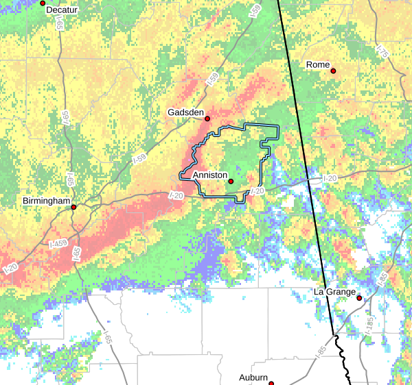
Radar valid at 142 am CST, Nov 30th 2022
ALC015-121-300830-
/O.NEW.KBMX.SV.W.0207.221130T0734Z-221130T0830Z/
BULLETIN - IMMEDIATE BROADCAST REQUESTED
Severe Thunderstorm Warning
National Weather Service Birmingham AL
134 AM CST Wed Nov 30 2022
The National Weather Service in Birmingham has issued a
* Severe Thunderstorm Warning for...
Northern Talladega County in east central Alabama...
Calhoun County in east central Alabama...
* Until 230 AM CST.
* At 134 AM CST, severe thunderstorms were located along a line
extending from near Ohatchee to near Lincoln to near Vincent,
moving east at 35 mph.
HAZARD...60 mph wind gusts.
SOURCE...Radar indicated.
IMPACT...Expect damage to roofs, siding, and trees.
* Locations impacted include...
Anniston, Oxford, Talladega, Jacksonville, Cobb Town, West End-Cobb
Town, Fort McClellan, Saks, Lincoln, Weaver, Riverside, Munford,
Ohatchee, Hobson City, Waldo, Alpine Bay Resort, Talladega
Superspeedway, Anniston Regional Airport, Blue Mountain and
Alexandria.
PRECAUTIONARY/PREPAREDNESS ACTIONS...
A Tornado Watch remains in effect until 600 AM CST for central
Alabama.
For your protection move to an interior room on the lowest floor of a
building.
&&
LAT...LON 3377 8564 3365 8564 3360 8574 3356 8575
3350 8590 3340 8592 3335 8598 3340 8638
3351 8628 3349 8625 3354 8619 3359 8622
3364 8617 3369 8620 3367 8615 3377 8604
3384 8606 3387 8564 3385 8564 3384 8559
TIME...MOT...LOC 0734Z 274DEG 31KT 3379 8608 3359 8618 3344 8641
HAIL THREAT...RADAR INDICATED
MAX HAIL SIZE...<.75 IN
WIND THREAT...RADAR INDICATED
MAX WIND GUST...60 MPH
Address/Location
Calhoun County EMA
507 Francis St W
Jacksonville, AL 36265
Contact
Emergency: 9-1-1
Non-emergencies: 256-380-5741